GERS is a Global Entity Referencing System that assigns stable, long‑lived identifiers to real‑world transportation entities, such as road segments. It enables consistent matching and integration of geospatial data across different digital maps and versions, reduces fragmentation caused by map updates, and supports interoperable data layering across systems and providers. GERS is developed and governed within the Overture Maps Foundation, where it is used to provide stable entity identifiers for Overture’s open transportation datasets. GERS is designed to be map‑agnostic and reusable beyond Overture: the identifiers can be associated with equivalent entities in other digital maps, allowing datasets referenced via GERS to be exchanged, compared, or integrated across different map ecosystems. |
GERS is a Global Entity Referencing System that assigns stable, long‑lived identifiers to real‑world transportation entities, such as road segments. It enables consistent matching and integration of geospatial data across different digital maps and versions, reduces fragmentation caused by map updates, and supports interoperable data layering across systems and providers. GERS is developed and governed within the Overture Maps Foundation, where it is used to provide stable entity identifiers for Overture’s open transportation datasets. GERS is designed to be map‑agnostic and reusable beyond Overture: the identifiers can be associated with equivalent entities in other digital maps, allowing datasets referenced via GERS to be exchanged, compared, or integrated across different map ecosystems.
Digital maps evolve continuously, and their representations change over time. Road geometries may shift, attributes such as speed limits or surface types may change, and modeling rules differ between map providers. As a result, map‑specific identifiers are frequently regenerated, breaking continuity for downstream applications such as traffic management, analytics, or infrastructure monitoring.
Without a stable reference layer, each data update requires repeated and costly re‑matching and conflation, i.e. a process of combining and aligning data from different sources so they refer to the same real‑world object. A global entity reference system addresses this by providing persistent identifiers that remain stable across map changes, enabling consistent association of data with the same real‑world entity over time, despite evolving map representations.
Different maps represent the same road in different ways. Segmentation rules, topology, and attribute modeling can vary significantly between providers or even between map versions of the same provider.
GERS addresses these differences by:
This allows different maps to align their data to the same real‑world entity reference, even when their geometries or attributes are not identical.
Relevance and rationale for using GERS as a stable location referencing method for various stakeholders can be summarized as follows:
GERS uses linear referencing principles to separate entity identity from attribute variation. Instead of splitting road geometry for every change (e.g. speed, lighting, surface), attributes are referenced along a stable base entity.
This approach provides the following benefits:
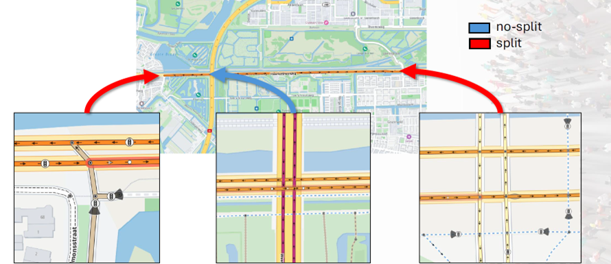
GERS applies a linear referencing–based segmentation approach in which each road is divided into stable, topologically connected sections defined by decision points, rather than by attribute changes. These decision points typically coincide with intersections or locations where a driver can make a routing decision (e.g. merge, diverge), and therefore define natural and stable boundaries in the transport network, see figure below.
Within this approach, all geometry segments between two decision points are merged into a single GERS entity and assigned a unique identifier. This ensures that a road section remains consistently identifiable over time, independent of how many attributes may change along it. Minor geometric shifts (e.g. due to map updates) do not affect the identity, as long as the topology remains unchanged. By basing segmentation on network topology rather than on attribute variation, GERS creates a stable reference layer that aligns with how users conceptually perceive roads—as connected sections between intersections—while minimizing unnecessary fragmentation of identifiers across map versions and providers.
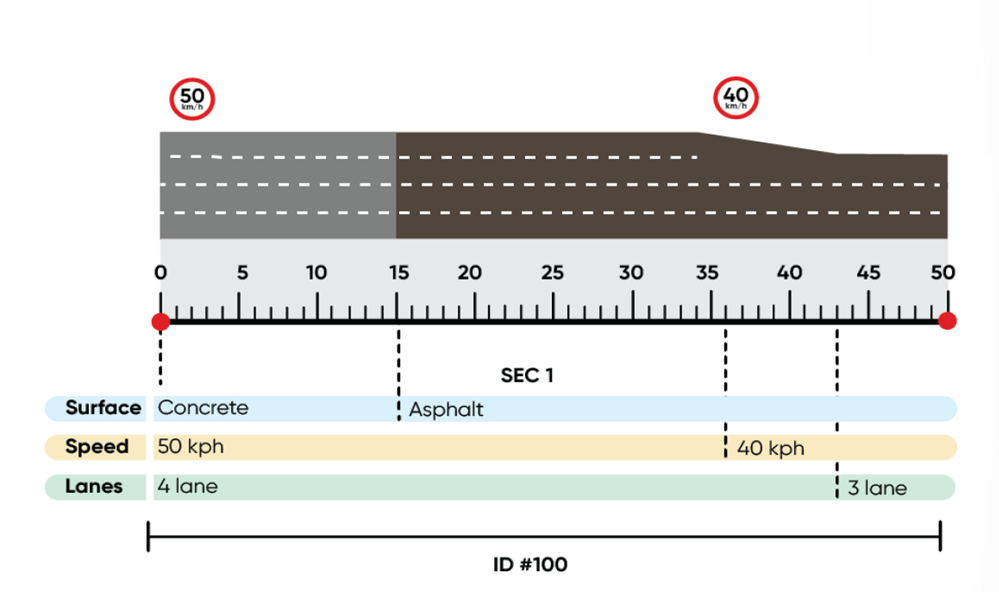
Within each stable GERS section, attribute variation is handled using linear referencing offsets, rather than by splitting the geometry. Instead of assigning a new identifier every time an attribute changes (e.g. speed limit, surface type, lighting), GERS retains a single section ID and expresses changes as positions along that section, see figure below.
These offsets indicate where along the section an attribute begins and ends. As a result, multiple attribute changes can coexist on the same base entity without affecting its identity. This avoids repeated segmentation and preserves the continuity of the road section, while still allowing precise localization of changes. This separation of entity identity (the section) and attribute variation (offset-based references) reduces identifier churn, avoids costly recalculation of dependent data (such as traffic flow or direction), and supports consistent data association across map updates and datasets.
GERS is supported by tooling that enables practical adoption:
Map sectioning services to build consistent base entities
Entity registries and explorers to inspect GERS IDs
Global Entity Matching tools (e.g. TomTom GEM) to align external datasets with GERS‑identified entities
These tools allow both public and private datasets to participate in a shared reference framework. See below in "References and Tools" for links to further information.
The “GERSification” process refers to the workflow by which external or newly available road network data is aligned with the GERS reference layer and assigned GERS identifiers. This process typically starts by matching incoming geometries against the existing GERS‑based transportation network. Below figure explains the "GERSification process using the TomTom Global Entity Matching process.
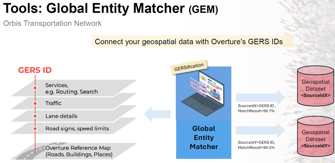
Where a correspondence is found, the external data can inherit the existing GERS IDs. Where no match exists—indicating missing or newly identified road geometry—the system identifies these gaps and assigns new GERS identifiers to previously unmatched sections, thereby extending the reference network. Once assigned, these GERS identifiers act as stable anchors that enable interoperability with other map ecosystems. The result is that data originally tied to a specific geometry (e.g. latitude/longitude or proprietary IDs) becomes referenced to a shared, map‑agnostic entity layer, enabling integration, exchange, and reuse across platforms.
This process is supported by matching and onboarding tools (such as global entity matching services), which automate the alignment and identifier assignment, ensuring that both public and private datasets can participate in a consistent global referencing framework.
| Requirement | GERS suitability | Notes |
|---|---|---|
| Long‑term stable entity identifiers | Excellent | GERS assigns identifiers to topological road sections between decision points, so they remain stable despite attribute changes and minor geometry updates. |
| Cross‑map data interoperability | Excellent | GERS provides a shared, map‑agnostic reference layer that enables alignment of data across different map models and providers. |
| Reduction of re‑conflation effort | Excellent | GERS reduces re‑conflation by maintaining stable IDs and using linear referencing instead of splitting the geometry for each attribute change. |
| Real‑time message encoding | Not the primary purpose | GERS is designed for persistent referencing and interoperability rather than for dynamic, on‑the‑fly message encoding. |
| Compact transmission format | Not applicable | GERS focuses on stable identification and integration, and therefore does not aim to provide a compact or bandwidth‑efficient encoding format. |
For understanding GERS as a method, the following references are useful:
GERS - Global Entity Reference System | Overture Maps - Overture Maps Foundation
| 1 | |||
| 2 | |||
| 3 |
GERS is a Global Entity Referencing System that assigns stable, long‑lived identifiers to real‑world transportation entities such as road segments. It enables consistent matching and integration of geospatial data across different digital maps and versions, reduces fragmentation caused by map updates, and supports interoperable data layering across systems and providers. GERS is developed and governed within the Overture Maps Foundation, where it is used to provide stable entity identifiers for Overture’s open transportation datasets. At the same time, GERS is designed to be map‑agnostic and reusable beyond Overture: the identifiers can be associated with equivalent entities in other digital maps, allowing datasets referenced via GERS to be exchanged, compared, or integrated across different map ecosystems.
Digital maps evolve continuously. Road geometries may shift, attributes such as speed limits or surface types may change, and modeling rules differ between map providers. As a result, map‑specific identifiers are frequently regenerated, breaking continuity for downstream applications such as traffic management, analytics, or infrastructure monitoring.
Without a stable reference layer, each data update requires costly re‑matching and conflation. A global entity reference system addresses this by providing persistent identifiers that remain stable across map changes, enabling data to be associated with the same real‑world entity over time, even as map representations evolve.
Different maps represent the same road in different ways. Segmentation rules, topology, and attribute modeling can vary significantly between providers or even between map versions of the same provider.
GERS addresses these differences by:
This allows different maps to align their data to the same real‑world entity reference, even when their geometries or attributes are not identical.
Relevance and rationale for using GERS as a stable location referencing method for various stakeholders can be summarized as follows:
GERS uses linear referencing principles to separate entity identity from attribute variation. Instead of splitting road geometry for every change (e.g. speed, lighting, surface), attributes are referenced along a stable base entity.
This approach:
 TBD: Explain picture below
TBD: Explain picture above and below
GERS is supported by tooling that enables practical adoption:
Map sectioning services to build consistent base entities
Entity registries and explorers to inspect GERS IDs
Global Entity Matching tools (e.g. TomTom GEM) to align external datasets with GERS‑identified entities
These tools allow both public and private datasets to participate in a shared reference framework.
Below figure explains the "GERSification process using the TomTom Global Entity Matching process
Explanation TBD
| Requirement | GERS suitability | Notes |
|---|---|---|
| Long‑term stable entity identifiers | Excellent | TBD |
| Cross‑map data interoperability | Excellent | |
| Reduction of re‑conflation effort | Excellent | |
| Real‑time message encoding | Not the primary purpose | |
| Compact transmission format | Not applicable |
For understanding GERS as a method, the following references are useful:
GERS - Global Entity Reference System | Overture Maps - Overture Maps Foundation